It was a spontaneous idea which turned into an unplanned spirit quest.
Scheduled to attend a conference in Scottsdale, Arizona, I thought it might be a good idea to take my first vacation after starting a new job. What better idea than to head out for a 3 1/2 day solo backpack trip before the meeting in January 2008? I had backpacked a whopping three times before: a 2-nighter in Grand Canyon in 1997, a weeklong Yosemite trip with guide in 2005, and a 2007 Sierra National Outing in the Nankoweap area of Grand Canyon (which Backpacker Magazine a month later declared the most difficult trail in Grand Canyon, but that wasn’t in the brochure …). In any case, I identified the Superstition Wilderness 60 miles East of Phoenix as my destination. Solo. No spot.
I got a copy of “Hiker’s Guide to the Superstition Wilderness” By J Carlson and E Stewart, packed my stuff, and went to Phoenix. On the flight, I figured out my final route. I would start at the Peralta trailhead toward Whiskey Springs, where I planned to stay the first night. From there, I would head through Upper La Barge Canyon along the Hoolie Bacon Trail, touch the Tortilla trailhead (really, Tortilla and bacon?!), and spend the night at Kane Spring. The third day would lead me through Peter’s Canyon across Peter’s Mesa back into La Barge Canyon. I would hike out through Needle Canyon, passing the Weaver’s Needle.
So, I picked up some cooking fuel at the Phoenix REI, bought a map, drove to the trailhead and set off. I was very excited and also quite nervous. I remember it was quite an achievement when I started hiking in the very safe forests around my hometown in my early 20s. Here I was, in the middle of an unfamiliar environment, solo, no such thing as a SPOT yet, and on my own. As I hiked through the Coffeeground Flats, so called because of the look of the fragile cryptobiotic desert soil, I noticed how busy my mind was. Soon, I got distracted. Spotting a bright green-leafed Ocotillo. Noticing the grave of an early settler. Spotting the Miner’s Needle. Watching the strange vegetation. And later, as the sun got lower into the sky, judging the distance to Whiskey Springs before nightfall. Yes, there was an illegal distillery there during prohibition … When I arrived there, sunset illuminated the canyon walls, with a full moon shining a bright light down on me.

Sunset at Whiskey Spring
I was in for one cold night! Deep down in the canyon, next to a creek, early sunset with late sunrise, 45 degree sleeping bag, probably not the best choice of campsite for the night. Clearly a beginners mistake! I managed to fall asleep with all my clothes, hat and gloves on. I did not know the trick with the warm water bottle in your sleeping bag either. When I woke up in the morning, the water bottle inside my tent was frozen solid. I guess this would mean about 10 F/-12 C outside at night. I waited until 9 am when the sun came up to get out of my tent.
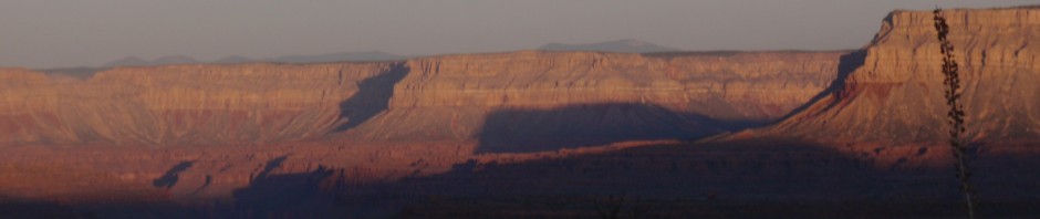
After breakfast, I headed down the trail and met two women who had camped fairly close to me. I also met three guys hiking a few minutes later. It was then that I started my tradition of engaging most people I meet on solo trips in a small talk. Why? Well, I guess if I ever disappear and there is a search going with my description, maybe one of those hikers I chatted with might remember that desert tortoise with a german accent. The chat turned out to be a good idea for yet another reason. The junction of the Whiskey Creek Trail to the Red Tanks Trail entering upper La Barge Canyon is a bit tricky to find. The hikers gave me a pretty good description how to locate the trail on the north side of the canyon. The shaded south canyon wall was covered with frozen seeps.

Ice in Upper La Barge Canyon
The Saguaros were fascinating for me. I had never seen a Saguaro “Forest”. Saguaros develop their first branch at age 60. There used to be a Saguaro with 40 branches somewhere in La Barge Canyon, but I recently heard this Methuselah was felled by a tornado. Even a cactus life has to end, but I hope it was a fulfilling one of several hundred years. And yes, sometimes the shape of the cactus caused me to chuckle – see upper right corner Saguaro in the picture below.

Saguaro in Upper La Barge
After coming out of the relatively short box canyon, I took the Hoolie Bacon Trail north (who came up with the names?) across Horse Ridge. The terrain changed dramatically, from deep canyons with steep canyon walls to rolling hills. The slightly higher elevation combined with a bit more available water created the right growing conditions for Juniper Trees. I had found my rhythm now, happily hiking along reflecting on my first 9 months living in California and other life events.

Junipers and Backpack
Some of the stream crossings proved to be a challenge. There just had been a period of heavy winter storms moving through the desert, causing flash floods to wash away all ducks and cairns. Especially when there were campsites adjacent to the river crossing, trail finding became a challenge. It was then that I learned how much I had relied on my hiking guides to do the trail finding for me so far. Now, I had no choice but get it done on my own. It was an exercise in paying attention to details. Openings in vegetations, footsteps. Paying attention to the map to find the general direction of the trail. And, lastly but most importantly, keeping a cool head instead of getting all flustered and stressed out about it! I eventually reached Tortilla trailhead, where some remains from cattle grazing days are still visible. With Whiskey, Bacon and Tortilla, this should make for a good dinner, no?

Tortilla Trailhead
I decided to hike on for about another hour, since I had the daylight left and figured I’d make good use of it. Smart idea, it turned out the next day. Wising up with campsite choice, I also had decided to look for a spot which would at least get early morning sun! Just before I found an ideal spot, I had the choice between crossing a stream or scrambling across a boulder with some brush. Given the temperatures, I chose the brush. At this spot was also the last time for the next 36 hours that I would encounter humans. Pretty remarkable for a place that is so close to Phoenix! Well, I found my spot, had a somewhat warmer night, and rested well.
Day 3 of my trip, I had my routine down. Only 6 miles to go on Peter’s Trail today, should be an easy hike. Or so I thought. The start of Peter’s trail was quite pleasant. I remember hiking slightly uphill, but I had forgotten about the huge boulder I found sitting next to the trail until I looked at my pictures again. Along this section of trail, I found a wide variety of smaller cacti growing, but almost no Saguaros.

Huge Boulder
To get into Peter’s Canyon, I had to hike over a small ridge. And got another lesson in desert hiking: Trails may disappear on ridges. I noticed when, hanging with my thoughts, I did not pay attention and ended up on what I first thought was trail, but turned out to be little washes crossing the trail. After a few times, I figured out that I really had to stay present and focused in this spot. Nevertheless, about 150 feet below the ridge I completely lost the trail. I spend another 20 minutes trying to find it, increasingly getting stressed and frustrated. Then, a breakthough. I looked at the map. I looked at the landscape. I noticed it was very clear where the trail had to cross the ridge. I could not possible get lost. So, off I trekked cross-country for the very first time in my life! I positively gloated when I found the trail right on the ridge where I expected it. Looking back where I came from, I got another remedial lesson in desert hiking: rails are much easier to spot from above than below. This would help me on future trips, when I lost trails, headed up the hill perpendicular to the trail, turned around, and could easily spot the trail below me.

Peter's Canyon
Peter’s Canyon was ethereal, stunning. It looks bland on the picture. But as soon as I stopped on the ridge to look down into the canyon, my ears were treated to a chorus of beautiful bird song. The cool desert air was filled with music! The mile hiking along the creek down-canyon was magical.
Finding the trail going up the wide gully you can see on the left in the photo above would have needed some magic. Again, cairns had been washed away. A campsite was on the other side of a 20-foot wide small stream. I Knew exactly that the trail had to be there. But alas, it took me a full 45 minutes to find it in the maze of deer trails, campsites, and washes. Cross-country was out of the question this time, because there was dense brush full of cat-claws. Even hiking on the trail, once I found it, left my arms looking rather bloody. Over all that trail-finding, I had lost a considerable amount of time and also forgot to eat and drink. Bad idea. I was pretty worn by the time I made it onto Peter’s Mesa. There is a photo of myself atop the Mesa I still laugh about. Another lesson learned. I took a long break before continuing the hike across the mesa. This section of the hike was not very interesting. At times, the trail came close to washes into Charlebois Canyon, but were way to steep to descent into. I was not used to canyon travel at this time and would not have dared to venture this far off trail in any case.

Nest of Cactus Wren
Towards the end of Peter’s Mesa, I had my first encounter with the famous Jumping Cholla. I saw several Cactus Wrens, the state bird of Arizona, and even found a nest. Now, how these birds can happily land on the Cholla and even live inside them without having to deal with the cactus spines remains a mystery to me.
I had contemplated camping on the mesa, but pressed on until I descended back into La Barge Canyon. I considered going all the way down, but then I spotted a wonderful campsite perched 200 feet above the canyon. It was a dry camp, meaning I would have to hike 15 minutes to water and back, but I still had enough with me for dinner and breakfast. I did not regret my choice. Being above the lowest point of the canyon, it was considerably warmer. The sun hit my tent earlier in the morning. The weather was warming up as well. Rewarded with a cozy night, I woke up to yet another remarkable view out of my tent. Take a look at the picture below. Why would anyone in their right mind trade this for a five star resort? 😉

Good morning, world! La Barge Canyon from my cozy sleeping bag.
Have you noticed that on the last day of your trip, Mother Nature always shows her most glorious side? I almost cried (ok, I did) because I did not want to leave. Yet it had to be done. The trail along La Barge Canyon is pleasant, with Blacktop Mesa looming overhead. The fallen Saguaro below was very interesting to me, because up to that point I had no idea what holds a cactus up, and how the inside of it looks like. Well, here you go.

Saguaro Skeleton
I left the Durchman’s trail to head back to the Peralta trailhead via the Terrapin Trail. There, I discovered Saguaros can also serve as Nature’s high rise condominiums. Two birds build their nests inside the Saguaro: The Gila Woodpecker stays at mid-level to drill 2-inch holes between the ribs. The Gilded Flicker builds higher up; therefore I assume these are Gilded Flicker nesting holes.
Shortly after I spotted this Saguaro, I heard voices and spotted two backpackers coming down over Black Top Mesa Pass. Those were the first people I encountered since the evening two nights before!

Natural high rise housing development
While hiking up Terrapin Canyon, I enjoyed the view of Weaver’s needle, which is a popular rock climbing spot. There are some wild stories from the mining days surrounding this place. If you, like me, enjoy the history of the American West, Superstition Wilderness will provide plenty of material.

Terrapin Trail toward Weaver's Needle
I made it back to the car, to the conference hotel with 10 minutes to spare for the rental car drop-off. One of the most funny memories in my life will be walking into this fancy Scottsdale resort dirty, dusty, sweaty, backpack in tow and the last shower 4 1/2 days ago. The front desk clerk managed to keep a straight face. However, there were some colleagues who walked right past by me without recognizing me (yes, you, Buddy!). I had a good laugh watching their face after saying hi. It obviously took them a few seconds to compute that the hobo in front of them was the same as the professor in business attire they had spend a few conferences and conference dinners with!
At the end of the conference, as I was leaving, I loaded my backpack into the airport shuttle and sat down next to someone on the bus. His first question to me: “Are you a backpacker?” And this is how I met my friend Anuj, who joined me for a backpack trip in Lassen National Park later the same year, helped entertain me the Christmas I was housebound with an allegedly broken ankle from a solo Death Valley trip the following year, and whose wedding I have the honor to attend tomorrow.
")
Where I am happy - Desert Tortoise 🙂

Great post, thanks!
Thinking of doing a backpacking trip in the Superstition Mountains. Loved reading your description, going with my dog Riley. What was your mileage? Any where to do some rock scrambling off trail, on your “route”?
Hi, I don’t remember exactly, but I did about 8-10 miles each day. Short days in February, plus I knew I would have to search for the trail at creek crossings because a storm at washed out trail markers just the week before. I generally stay on established trails in the desert, because the desert soil is so fragile. There was only one section where I had to go cross country for a 1/4 mile, but that was because the trail was truly not visible. Hiking up the washes is usually the best option to avoid any extra erosion.
Hi, I don’t remember exactly, but I did about 8-10 miles each day. Short days in February, plus I knew I would have to search for the trail at creek crossings because a storm at washed out trail markers just the week before. I generally stay on established trails in the desert, because the desert soil is so fragile. There was only one section where I had to go cross country for a 1/4 mile, but that was because the trail was truly not visible. Hiking up the washes is usually the best option to avoid any extra erosion.